Office Address
14, Residency Road, Udaipur, Rajasthan 313001
Office Address
14, Residency Road, Udaipur, Rajasthan 313001

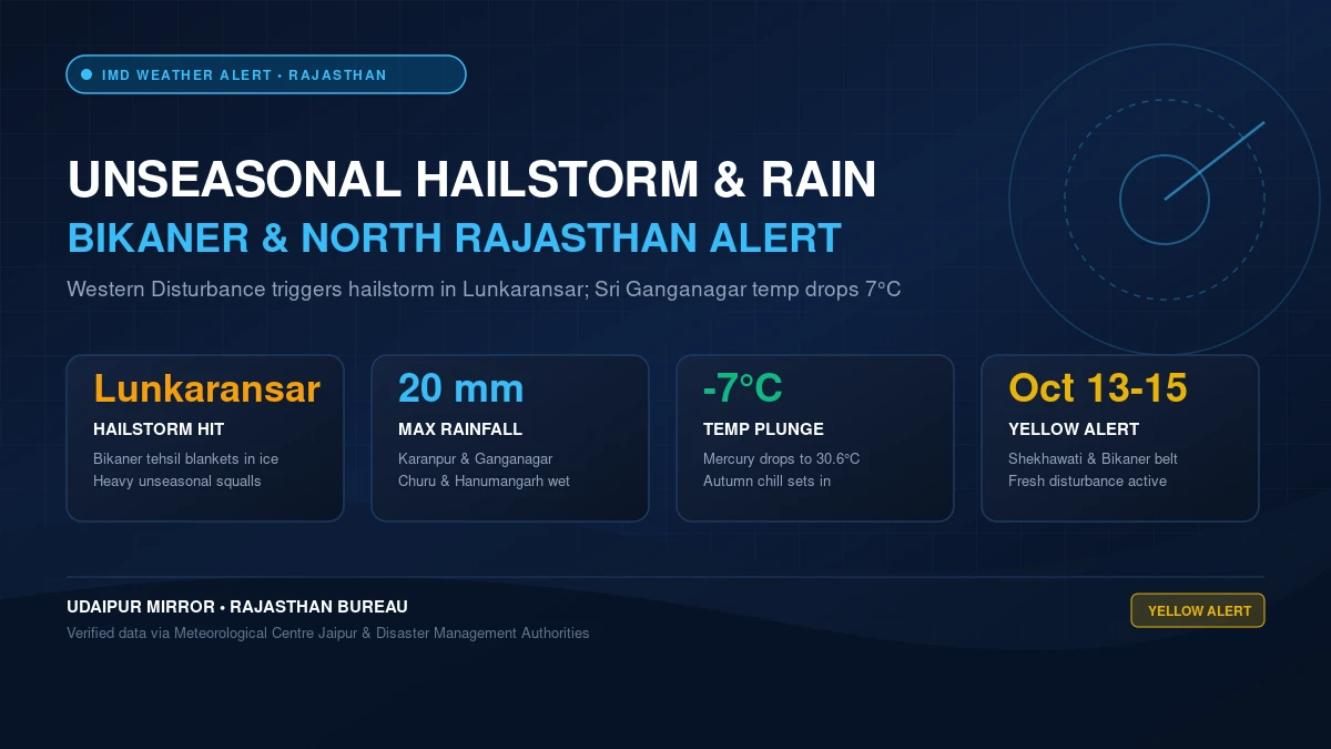
In a dramatic shift in meteorological conditions across northwestern India, a vigorous Western Disturbance has triggered unseasonal squalls, thunderstorm activity, and a sudden rajasthan weather update bikaner hailstorm rain alert across several northern and western districts. On Sunday, intense weather patterns brought a destructive hailstorm to Lunkaransar tehsil in Bikaner district, alongside widespread rainfall in Sri Ganganagar, Churu, and Hanumangarh that measured up to 20 mm, driving day temperatures down by as much as 7°C.
The abrupt downpour has effectively ended weeks of relentless post-monsoon heat, ushering in early autumn chill across northern Rajasthan. With an active secondary atmospheric disturbance tracking across western Rajasthan and Pakistan border frontiers—an area undergoing vast infrastructure shifts as detailed in our analysis of the Western Rajasthan Renewable Energy Corridor—the Meteorological Centre Jaipur (IMD) has issued a formal Yellow Alert forecasting continued thunder squalls, lightning, and intermittent rain through October 15, 2026.
The most severe manifestation of Sunday’s atmospheric instability occurred in Lunkaransar, a key agricultural and pastoral tehsil in Bikaner district. Residents and rural farmers reported a sudden darkening of the sky in the afternoon, followed by gale-force winds and a heavy hailstorm that blanketed agricultural fields, residential rooftops, and rural highway shoulders with white ice pellets.
The sudden barrage forced highway traffic on the Bikaner–Suratgarh corridor to a complete standstill for nearly half an hour due to zero visibility and slippery road conditions. While the hailstorm was localized to Lunkaransar and adjoining villages, strong surface winds gusting up to 45 km/h whipped across the wider Bikaner division, tossing loose tin sheds and bending roadside trees.
Local revenue and tehsildar administrative teams have been placed on alert to assess any immediate physical damage to standing crops, particularly open cotton fields and harvested oilseed produce lying in regional rural grain markets (mandis).
Simultaneously, the northern border belt encompassing Sri Ganganagar, Hanumangarh, and Churu experienced continuous bouts of moderate to heavy rainfall throughout Sunday and early Monday. Sri Ganganagar district bore the brunt of the wet spell, logging substantial localized accumulation that waterlogged roads and low-lying market colonies.
Official meteorological measurement stations across Sri Ganganagar documented significant precipitation totals across multiple revenue blocks:
Adjacent districts also logged notable weather activity. Churu and Hanumangarh witnessed rainfall reaching between 10 mm and 20 mm across selective tehsils, accompanied by dense dark cloud formations. In Shekhawati’s Jhunjhunu district, areas including Pilani reported sudden evening rain spells accompanied by blustery winds, significantly dampening the dust-laden air.
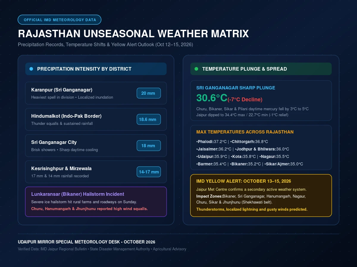
The primary consequence of this unseasonal weather outbreak is a steep reduction in daytime temperatures, bringing sudden respite from October’s oppressive daytime humidity. Sri Ganganagar registered the sharpest thermal fall in the state, with daytime maximum temperatures plunging by a staggering 7°C to settle at 30.6°C—well below normal seasonal baselines.
Other northwestern districts recorded temperature drops between 3°C and 5°C. In Churu, Bikaner, Sikar, and Pilani, day temperatures hovered around 35°C, with brisk northerly winds imparting a distinct autumn coolness by late evening. In state capital Jaipur, cloudy intervals and cool breezes caused day and night temperatures to shave off approximately 1°C, registering 34.4°C maximum and 22.7°C minimum.
While northern Rajasthan chilled under cloud cover and hailstorms, southern and central districts experienced relatively warmer, dry conditions before the seasonal transition fully descends toward Mewar, as chronicled in our report on Udaipur’s lake conservation and winter tourism preparedness. Official maximum temperatures recorded across Rajasthan included:
According to weather bulletins released by Radheshyam Sharma, Director of the Meteorological Centre Jaipur, this is not an isolated event. A secondary weather system is actively developing over north Pakistan and adjoining Punjab-Rajasthan borders. Under its influence, moist westerly winds are projected to interact with continental troughs over northwest India.
The IMD has officially issued a Yellow Alert effective from October 13 through October 15, 2026 for seven critical districts:
During this period, these districts are likely to experience partly cloudy to overcast skies, localized thunder, lightning strikes, and gusty winds ranging between 30 and 40 km/h. Isolated pockets may also witness light to moderate rain showers. Conversely, southern, eastern, and south-eastern Rajasthan—including Udaipur, Kota, and Bharatpur divisions—are anticipated to remain predominantly dry with clear sunshine.
The unexpected rainfall and hailstorm have triggered mixed reactions across the state’s agrarian heartland:
With Western Disturbances marking their presence early this season, the state’s transition toward winter is set to accelerate significantly over the coming weeks.
Add Udaipur Mirror as a preferred source on Google to see more of our travel guides in your AI overviews.